Weather Forecast -- April 2026
2026 Hurricane Season: CSU Predicts Below-Average with El Niño
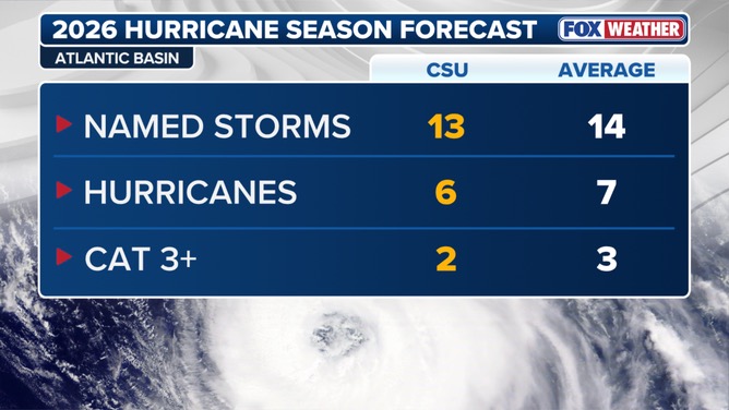
CSU forecasts 13 named storms, 6 hurricanes, 3 major. Super El Niño expected to suppress Atlantic activity.
Published: April 13, 2026
- CSU forecasts 13 named storms, 6 hurricanes, and 3 major hurricanes -- a below-average season driven by Super El Nino conditions.
- US landfall probability: 44% (below the 52% average). Caribbean landfall: 37% (below 47% average).
- El Nino increases upper-level wind shear across the Atlantic, suppressing tropical cyclone formation and intensification.
- Compared to 2025 (18 named storms), the 2026 season shows a notable decline -- yet it only takes one major hurricane making landfall to cause devastating damage.
CSU Forecast Numbers Breakdown
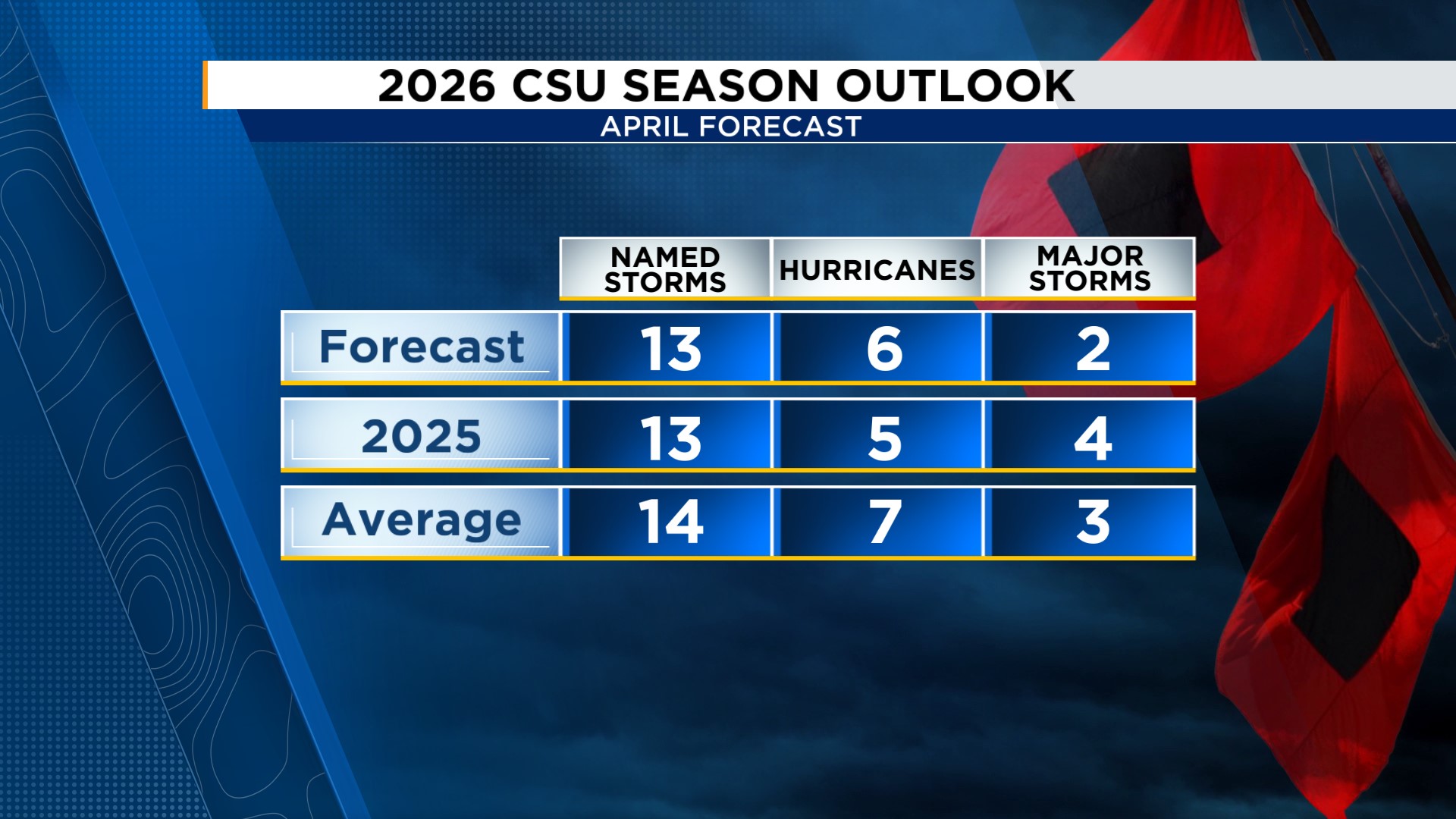
The research team led by Dr. Phil Klotzbach at Colorado State University released their 2026 Atlantic hurricane season forecast on April 9, 2026. The outlook calls for a somewhat below-average season, with the following specific metrics:
2026 Forecast vs. Average (1991-2020)
According to CSU's report, the 2026 season is forecast below average for named storms and hurricanes, but major hurricane activity (Category 3+) matches the long-term average.
Super El Nino and Its Impact on Hurricane Season
The primary factor suppressing Atlantic hurricane activity in 2026 is the developing Super El Nino -- an abnormal warming of sea surface temperatures in the central and eastern equatorial Pacific. Here is how El Nino affects Atlantic hurricanes:
Wind shear is the change in wind direction or speed with altitude. Strong wind shear disrupts the convective column -- the vertical structure that tropical cyclones need to sustain and intensify. This is why El Nino is the single most important predictor for Atlantic hurricane season activity.
Historical Comparison: 2025 vs. 2026 Forecast
The 2025 season occurred under La Nina conditions -- the opposite of El Nino. La Nina reduces wind shear over the Atlantic, creating favorable conditions for hurricane development. The result was 18 named storms, well above the long-term average.
| Metric | 2025 (actual) | 2026 (forecast) | Average |
|---|---|---|---|
| Named Storms | 18 | 13 | 14 |
| Hurricanes | 9 | 6 | 7 |
| Major Hurricanes | 4 | 3 | 3 |
| ENSO Phase | La Nina | El Nino | -- |
Note: Forecasts are statistical probabilities. The 2005 season (Katrina) was initially forecast as "below average" but became one of the most devastating on record. A single major hurricane making landfall can cause billions in damage regardless of overall seasonal activity.
Landfall Probabilities by Region
CSU also provides landfall probability estimates for key regions. All 2026 figures are at or below the long-term average, reflecting the suppressive effect of El Nino conditions.
ZestLab analysis: The major hurricane US landfall probability (21%) matches the long-term average -- meaning Category 3+ risk persists even in a below-average season. Coastal residents should still maintain hurricane preparedness plans.
Saffir-Simpson Hurricane Wind Scale
The Saffir-Simpson scale classifies hurricanes from Category 1 (weakest) to Category 5 (strongest) based on sustained wind speed. Category 3 and above are classified as "major hurricanes" -- the level CSU forecasts 3 of in 2026.
Hurricane Preparedness Checklist
Even though the 2026 season is forecast below average, preparation remains critical. A single major hurricane landfall can cause catastrophic damage.
Create an evacuation plan
Know your local evacuation routes and gathering points. Inform family and neighbors.
Build an emergency kit
Water (1 gallon/person/day for 3 days), canned food, flashlights, batteries, medications, important documents.
Fortify your home
Inspect roof, windows, and drainage systems. Install storm shutters if in a coastal zone.
Stay informed
Sign up for alerts from the National Hurricane Center and local emergency management agencies.
Review insurance
Check homeowner and flood insurance policies. Flood insurance typically has a 30-day waiting period.
Vietnam and the 2026 Typhoon Season: A Pacific Parallel
While El Nino suppresses Atlantic hurricanes, its effect on the western Pacific is more complex. For the South China Sea and Vietnam, El Nino typically causes:
- Fewer typhoons form in the western Pacific, but those that do may intensify more due to warmer sea surface temperatures.
- Storm tracks tend to shift eastward, reducing the probability of direct hits on Vietnam.
- Vietnam's typhoon season runs from June through November, coinciding with the Atlantic hurricane season.
- Under Super El Nino, Vietnam may face fewer typhoons but increased drought and heat risk -- particularly in the Central and Southern regions.
ZestLab analysis: El Nino is a double-edged sword -- fewer typhoons but increased drought. Central Vietnam residents should monitor both typhoon forecasts and temperature/rainfall projections for summer 2026.
Frequently Asked Questions
References
Related Articles
Related Topics
Stay on top of trends
Bookmark this page and check back often for the latest updates and insights.