SUPER TYPHOON
SINLAKU
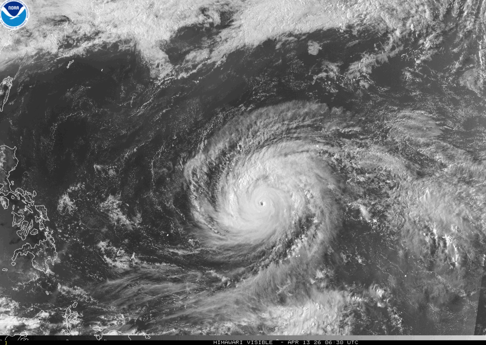
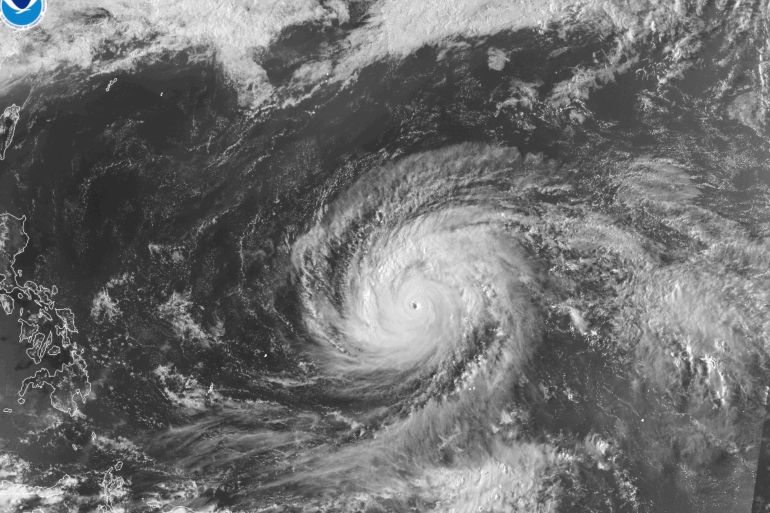
Category 5 Sinlaku with 278 km/h winds bore down on Guam and Northern Mariana Islands on April 14.
Key Takeaways
Super Typhoon Sinlaku formed April 9, becoming the strongest storm of 2026 with maximum sustained winds of 278 km/h (173 mph) — Category 5 equivalent.
As of April 14, the storm center is 126 km southeast of Saipan. The Northern Mariana Islands face Category 4-5 conditions.
Guam is under a tropical storm warning and typhoon watch with 40-50 mph winds (gusts 65 mph), but is expected to avoid a direct hit.
Dangerous seas are forecast through Thursday. Flooding remains the primary threat to Guam.
The storm's April formation is unusually early, linked to warmer-than-average sea surface temperatures.
Storm Statistics
Sinlaku's 278 km/h winds exceed the 252 km/h threshold for Category 5, the highest level on the Saffir-Simpson scale. At this intensity, winds can destroy framed homes and topple large trees.
Path and Tracking
Sinlaku formed from a tropical disturbance east of the Philippines on April 9, 2026. Within 72 hours, the system rapidly intensified from a tropical depression to a super typhoon, fueled by unusually warm sea surface temperatures (SSTs) of 29.5 degrees Celsius in the formation area — roughly 1.2 degrees above the seasonal average.
The storm center is tracking west-northwest at approximately 20 km/h. According to the Joint Typhoon Warning Center (JTWC), the forecast track brings the eye over or near Saipan and Tinian within the next 24-36 hours before a northward recurvature into the open Pacific.
The cone of uncertainty still includes Guam in worst-case scenarios. While the average track passes north of Guam, the 48-hour average forecast error for Western Pacific super typhoons is 150-200 km.
Guam Impact
Although Guam is expected to avoid a direct hit, the island faces significant impacts. The National Weather Service (NWS) in Guam has issued a tropical storm warning and typhoon watch for the entire island.
Expected Conditions on Guam
Flooding is the primary threat to Guam. Rainfall of 4-8 inches combined with storm surge can cause significant flooding in low-lying areas, particularly around Hagåtña and Tumon Bay.
Northern Mariana Islands
The Northern Mariana Islands (NMI) face direct Category 4-5 conditions. Saipan, Tinian, and Rota are in the direct path of Super Typhoon Sinlaku.
The NMI Governor has issued mandatory evacuation orders for all residents in low-lying and coastal zones on Saipan, Tinian, and Rota. Typhoon shelters have been activated. With a population of roughly 47,000, the NMI has limited infrastructure to withstand Category 5 conditions.
Winds above 250 km/h are expected on Saipan within 24-36 hours. Dangerous seas with 6-10 meter waves will persist through at least Thursday, April 17. Widespread power outages and communications disruptions are near-certain.
Storm Timeline
Tropical Depression Forms
A tropical disturbance east of the Philippines developed into a tropical depression. JTWC began tracking the system with initial forecasts indicating rapid intensification potential due to unusually high SSTs.
-- Sea temps at 29.5C — 1.2C above average, providing enormous energy for storm development.
Tropical Storm Intensification
The system rapidly intensified into Tropical Storm Sinlaku with 95 km/h sustained winds. An eye began forming on satellite imagery. The Philippines raised warnings for eastern sea zones.
-- Intensification rate doubled initial forecasts — an early warning sign of super typhoon potential.
Explosive Intensification to Super Typhoon
Sinlaku underwent explosive intensification, going from tropical storm to super typhoon in just 36 hours. Sustained winds reached 278 km/h with a well-defined 25 km diameter eye. JTWC classified it as Category 5 equivalent.
-- At 278 km/h, Sinlaku became the world's strongest storm of 2026 — more powerful than any hurricane in the 2025 Atlantic season.
Threatening NMI, Guam on Alert
The storm center is 126 km southeast of Saipan and closing in. Guam is under a tropical storm warning, NMI under a typhoon warning. Mandatory evacuations issued. Saipan airport closed.
-- Approximately 47,000 NMI residents brace for the strongest storm to hit the islands since Super Typhoon Yutu in 2018.
Historical Context
The Northern Mariana Islands were hit by Super Typhoon Yutu in October 2018, the strongest storm to ever make landfall on U.S. territory with 280 km/h winds. Yutu caused an estimated $800 million in damage and destroyed more than 1,000 homes on Saipan and Tinian.
Sinlaku matches Yutu's intensity closely but formed much earlier — April versus October. On average, the Western Pacific sees only about 0.7 tropical storms in April per year, and a super typhoon this month is extremely rare.
Comparison: Sinlaku vs. Yutu (2018)
| Metric | Sinlaku (2026) | Yutu (2018) |
|---|---|---|
| Max winds | 278 km/h | 280 km/h |
| Category | Cat 5 equivalent | Category 5 |
| Month of formation | April | October |
| Areas affected | NMI + Guam | NMI (Saipan, Tinian) |
| Warning lead time | ~5 days | ~3 days |
Climate Connection
Sinlaku's unusually early April formation has drawn attention from climatologists. Sea surface temperatures (SSTs) in the formation area reached 29.5 degrees Celsius — 1.2 degrees above the climatological average. Research suggests each 1 degree Celsius increase in SSTs can boost a tropical cyclone's maximum wind speed by 5-8%.
The global ocean warming trend, particularly in the Western Pacific, has been documented in numerous recent studies. According to ZestLab analysis, 2025 and early 2026 saw average Western Pacific SSTs running 0.8-1.5 degrees Celsius above the 1991-2020 baseline, depending on the subregion.
Vietnam Typhoon Season Parallel
While Sinlaku is active in the Western Pacific far from the South China Sea, the trajectories of early-season super typhoons serve as an important indicator for Vietnam's typhoon season (typically June through November). If SSTs remain elevated, Vietnam could face a more active typhoon season than average.
According to Vietnam's National Centre for Hydro-Meteorological Forecasting, 2026 is expected to see 12-14 storms and tropical depressions in the South China Sea, with 5-7 potentially making direct landfall. Central Vietnam, particularly from Da Nang to Binh Dinh, remains the most vulnerable region.
-- With roughly 95 million people living in vulnerable coastal zones, the NMI's experience with Sinlaku offers critical lessons for Vietnam ahead of its own typhoon season.
Typhoon Safety Tips
Before the Storm
- -Stock drinking water (1 gallon per person per day for 5 days)
- -Charge devices, prepare backup batteries
- -Secure medications and important documents in waterproof bags
- -Board up windows, clear outdoor objects
During the Storm
- -Stay indoors, away from windows
- -Do not go outside during the eye (winds reverse suddenly)
- -Move to higher floors if flooding occurs
- -Monitor official weather sources only
After the Storm
- -Avoid downed power lines and flood water
- -Check structural integrity before re-entering buildings
- -Use bottled water until tap water is confirmed safe
- -Report damage to local authorities
Frequently Asked Questions
References
- Al Jazeera — Super Typhoon Sinlaku bears down on Northern Mariana Islands, Guam (April 14, 2026)
- Joint Typhoon Warning Center (JTWC) — Western Pacific Tropical Cyclone Advisory, April 2026
- National Weather Service, Guam Weather Forecast Office — Tropical Storm Warning and Typhoon Watch, April 14, 2026
Related Topics
Stay on top of trends
Bookmark this page and check back often for the latest updates and insights.